


L'Endre et Catchéou

aljac
User
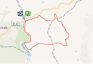

Length
9.4 km

Max alt
81 m

Uphill gradient
115 m
Km-Effort
10.9 km

Min alt
19 m

Downhill gradient
116 m
Boucle
Yes
Creation date :
2023-11-28 20:28:17.595
Updated on :
2023-11-28 20:30:53.583
2h28
Difficulty : Medium

FREE GPS app for hiking
 SityTrail
IGN / Geographical institutes
SityTrail Plus
The world is yours!
About
Trail Walking of 9.4 km to be discovered at Provence-Alpes-Côte d'Azur, Var, Le Muy. This trail is proposed by aljac.
Description
Beau parcours très marchant en terrain plat.
Positioning
Country:
France
Region :
Provence-Alpes-Côte d'Azur
Department/Province :
Var
Municipality :
Le Muy
Location:
Unknown
Start:(Dec)
Start:(UTM)
305228 ; 4819656 (32T) N.
Comments